Across the Nullarbor: Part 2
(Note: This is the second part of my Nullarbor adventure. Click here for Part One.)
DAY 4
The rain spit on Fowlers Bay all night long but I was cozy and dry in my tent and slept like a log. Kylie woke the crew at 6 a.m. with am impression of an asthmatic rooster. Having been two hours behind schedule the day before, she was determined to keep up with the itinerary on day four. I crawled out of my tent to a dark wet morning, ready another day as a Nullarbor Traveller.
About an hour outside Fowlers Bay we stopped by the side of the highway for no apparent reason. Kylie explained that we had just crossed the Dingo Fence, the longest man-made structure on the planet (yes, longer than the Great Wall of China). The 5,641-kilometer fence keeps the wild dingos (the dogs that are Meryl Streep’s baby) in the western half of the country. It is meant to protect livestock from the canine predators, but the plan has backfired. Without dingos, feral cats and rabbits have become a huge problem. The government is debating whether to cut holes in the fence every few kilometers to reintroduce the dingo into the east and cut down the cat and rabbit population. (For more on how introduced species create havoc in Australia, rent the fantastic documentary “Cane Toads.”)
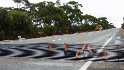
Where the Dingo Fence crosses the highway there is a metal grate that the dogs will not cross. There is room to crawl under the road and stick your hands through the grate. A few of us did this for a lark while Kylie snapped pictures.
As we were now on the true Nullarbor, services were few and far between. Most of the traffic is road trains, and the businesses on the route all cater to the trucker drivers. Dotted on the landscape are a handful of “roadhouses” offering fuel, food, showers and toilets and sometimes a place to sleep. Prices are steep and we avoided buying supplies if possible. And no, Patrick Swayze was not spotted at any of the roadhouses.
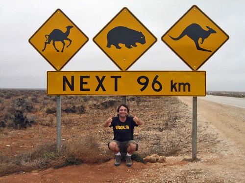
Just past the Nullarbor Roadhouse we stopped for pictures at the famous Camel-Wombat-Kangaroo Crossing sign. There is little to attract the eye on the Nullarbor other than scrub and sky, so road signs became a major attraction. This one tops them all. Unfortunately, we didn’t see any camels, wombats or kangaroos the entire 96 kilometers.
To break up the drive we stopped at the Bunda Cliffs in Nullarbor National Park and walked through the sand dunes at Eucla to visit the ruins of an old telegraph station on the border of South Australia and Western Australia.
The Bunda Cliffs show three layers of geological sediment. The bottom layer of white limestone was formed between 70 and 90 million years ago when the Nullarbor was covered in ocean. The weather was still overcast but the views were still spectacular. The pictures don’t show the extent of the views. I did enjoy a sign warning tourists of the danger of the cliffs – no words, just a picture of a stickman tumbling to his doom.
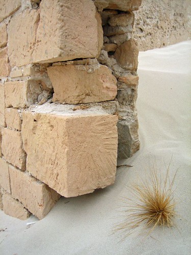
The Eucla Telegraph Station used to convey messages between the states of South Australia and Western Australia. Legend says the telegraph operators in each state hated each other and never spoke, even though they spent all day in adjoining rooms. Their only contact came when exchanging telegraph messages. The station was buried by by the sand dunes for about 80 years, when vegetation kept the sand in place. But rabbits ate all the foliage and the sand shifted again, exposing the ruins below.
Day four ended with a night of true bush camping – no facilities, no neighbors, nothing but our crew and the desert. Kylie taught me how to make damper, Australian bread. You mix flour, self-rising flour and water, throw in a few dried fruits, knead and shape, then sprinkle the top liberally with sugar. Once the campfire embers are nice and hot, you put the loaf into a covered pan and place in the fire. Twenty minutes later, you’ve got yourself a loaf of doughy, sweet bread. Slice and top with yogurt and Bob’s your uncle. (I don’t actually know what “Bob’s your uncle” means, but I like the sound of it.)
DAY 5
Kylie made an executive decision on day five to forego another night of bushcamping in favor of a long day of driving to Lucky Bay at Cape Le Grand National Park, where we would set up for three nights in one location. Along the way we stopped to stretch our legs at a two of the caves on the Nullarbor. As I’ve mentioned, the Nullarbor is composed of limestone, which is prone to erosion, which forms caves.
The Nullarbor Traveller tour used to include an afternoon of swimming in an underground freshwater pool at Cocklebiddy Cave. But a cave-in a few years ago left the cave unstable and the Parks Department closed it to visitors.
There is also an interesting story associated with Cocklebiddy Cave. About ten years ago, a group of scientists set out to map the cave using scuba equipment, spelunking up to four kms under the desert floor. One day an Aboriginal woman, Maureen, appeared out of the bush and told the scientists that Cocklebiddy is a sacred Aboriginal site and that should ask the Rainbow Serpent (a vital player in many Aboriginal creation stories) for permission before entering the cave. The scientists scoffed at the idea and entered the cave. Observers claim a brown snake appeared in the desert and followed the men into the cave.
Soon thereafter, a cloud in the shape of a snake appeared in the sky and let loose with a torrential downpour, dropping 40 milliliters in an hour in a region that gets less than that annually. The cave entrance crumbled, trapping the divers inside for two days. When they were finally rescued, witnesses saw the snake follow the men out of the cave.
I don’t know if I believe this story, but the storm was documented and multiple witnesses claim they saw the snake and Maureen. Was she a ghost? Was the snake the Rainbow Serpent? Nobody knows.
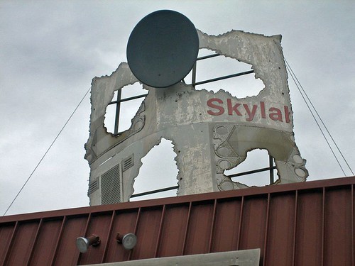
Back into the bus for the long drive to Lucky Bay we cover the 90-Mile Straight, the longest stretch of straight road in Australia, and then stop in Balladonia for fuel and to admire a piece of Skylab mounted on the roof of the roadhouse. I remember hearing about Skylab falling from space in 1979. The news described the area as a remote part of “Outback Australia.” I never intended to visit the area but was pleasantly surprised to pass through. The small museum documenting the event was closed for repairs. I will have to look it up on Wikipedia someday.
We arrived at Lucky Bay as the sun was setting, and after logging 731 kilometers on the day set up camp for the next three nights.
DAY 6
For the first time on this trip, I slept past 8. I woke to kangaroos, a mother and her joey, nibbling their breakfast in the middle of the campground, unconcerned about the humans in their midst.
We piled into the bus for the 50 km drive to the city of Esperance (Population 15,000), the first town of any significance that we’d seen since Port Augusta on day one. After just five days in the bush, I was struck by our return to civilization. I’m a big fan of electricity (and hot showers), a fact I’m sure of after being without for a few days.
We toured the town’s white-sand beaches, rated as the best in Australia, before Kylie let us loose for 90 minutes of lunch and shopping. I ate a huge hamburger, caught up on email and bought an Australian power chord for my laptop.
Back at Lucky Bay, the wind was whipping and the sea too rough for swimming. So we made a mockery of cricket on the beach before a late afternoon bushwalk.
In the late afternoon, we set out for Frenchman Peak, a granite mountain no more than 800 feet tall, but still the highest feature of the landscape. A slow, steep climb brought us to the top of Frenchman, the wind whipping harder and keeping me off balance while enjoying the 360-degree view. Kylie handed out squares of toilet paper and we all let go at once to see whose square would fly the farthest. Mine landed in a bush about ten feet away.
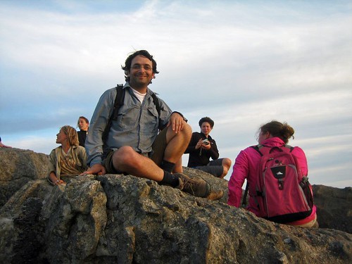
Back in camp, Kylie said it was time to learn about the Tim Tam orgasm. I broke out the bottle of Jack Daniel’s I’d bought in Port Augusta and Kylie brought out the Tim Tams. Tim Tams are made of two rectangular cookies with a cream middle and a chocolate coating. The trick is to nibble off opposite corners, then suck the Jack Daniel’s from a cup into the cookie’s interior. Crunch, smile, yum. You can use milk, tea, coffee, any liquid you want instead of Bourbon. But the combination of Jack Daniel’s and chocolate is hard to beat.
DAY 7
The morning of our second full day at Lucky Bay was spent hiking from Cape Le Grande Beach to Hellfire Bay, a 3-hour trek through coastal scrub, over marbled granite slopes and across a beautiful white sand beach. The swim with the sea lions on day two will forever be the highlight of this tour, but this hike ranks a close second. It felt great to get out and spend quality time tramping through the bush.
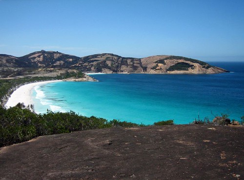
After the hike, a swim in the crystal clear water at Lucky Bay and then a BBQ dinner that included kangaroo sausages (‘Roo Bangers). The meat is tasty, not like chicken, but the prospect of kangaroos bouncing through camp while I was chomping on a sausage dampened the experience.
DAY 8
Not every day on a tour can be great, and day 8 sucked.
Here’s the short version: a long day of driving, no hike at Bluff Knoll due to bad weather, the winery shut for the day and the land around the campground decimated by a bushfire the week before.
Still, it was nice to leave the desert behind and enter a landscape with forest and greenery. We also passed through the Fitzgerald Biosphere, an area of 330,000 square kilometers where 75% of the plants and animals do not occur anywhere else in the world. One example is Australia’s most deadly snake, the Dugite. We didn’t see one.
DAY 9
With mixed emotions, I rose for the last day of the tour. It had been a lot of fun, and we’d covered a lot of ground, but I was ready to see a city and check in with the news of the world.
There rain continued as we entered the Valley of the Giants outside of Walpole for a tree-top walk among old-growth Red Tingle eucalypts. A series of suspension bridges form a 600-meter loop through the forest canopy. The steel walkways sway 40 meters above the forest floor, offering spectacular views of the trees and the ground below. As we begin the walk, the clouds part, the sun starts shining and the whole forest glistens.
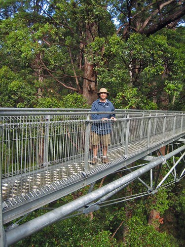
We stopped for lunch at the Diamond Tree Fire Lookout, a eucalypt more than 50 meters tall with a series of spikes circling the truck to form a ladder and a small cabin perched at the top. A fire ranger would climb the tree in the morning and spend all day scanning the horizon for smoke. A small black PVC pipe carries waste from the top to a chamber on the ground. I climb about 30 feet before freaking out and descending for lunch. Without ropes or a harness, it felt too high, too exposed and too unsafe for a 40-year-old with wonky depth perception.
A few hours later, we pass through Bundury and Kylie points out the first traffic light in 3,900 kilometers. An hour later we are in Perth and the tour is over. We’ve covered the distance from London to Moscow with no injuries, no fights and smiles all around.
When I look back on my nine days crossing the Nullarbor, I recall the swim with sea lions, the desolation of the plain, the road trains, hiking and camping at Lucky Bay. The names of towns run through my mind – Iron Knob, Widunna, Venus Bay, Streaky Bay, Penong, Fowler Bay, Caiguna, Balladonia, Eucla, Madura, Esperance, Jerramungup, Porongurup – places I will probably never see again, but am happy to have seen once. If you are ever in Australia with nine days to kill, travel across the Nullarbor. You won’t regret it.
Flickr Photo Set: Across the Nullarbor (147 Photos)
DAY 4
The rain spit on Fowlers Bay all night long but I was cozy and dry in my tent and slept like a log. Kylie woke the crew at 6 a.m. with am impression of an asthmatic rooster. Having been two hours behind schedule the day before, she was determined to keep up with the itinerary on day four. I crawled out of my tent to a dark wet morning, ready another day as a Nullarbor Traveller.
About an hour outside Fowlers Bay we stopped by the side of the highway for no apparent reason. Kylie explained that we had just crossed the Dingo Fence, the longest man-made structure on the planet (yes, longer than the Great Wall of China). The 5,641-kilometer fence keeps the wild dingos (the dogs that are Meryl Streep’s baby) in the western half of the country. It is meant to protect livestock from the canine predators, but the plan has backfired. Without dingos, feral cats and rabbits have become a huge problem. The government is debating whether to cut holes in the fence every few kilometers to reintroduce the dingo into the east and cut down the cat and rabbit population. (For more on how introduced species create havoc in Australia, rent the fantastic documentary “Cane Toads.”)
Where the Dingo Fence crosses the highway there is a metal grate that the dogs will not cross. There is room to crawl under the road and stick your hands through the grate. A few of us did this for a lark while Kylie snapped pictures.

As we were now on the true Nullarbor, services were few and far between. Most of the traffic is road trains, and the businesses on the route all cater to the trucker drivers. Dotted on the landscape are a handful of “roadhouses” offering fuel, food, showers and toilets and sometimes a place to sleep. Prices are steep and we avoided buying supplies if possible. And no, Patrick Swayze was not spotted at any of the roadhouses.
Just past the Nullarbor Roadhouse we stopped for pictures at the famous Camel-Wombat-Kangaroo Crossing sign. There is little to attract the eye on the Nullarbor other than scrub and sky, so road signs became a major attraction. This one tops them all. Unfortunately, we didn’t see any camels, wombats or kangaroos the entire 96 kilometers.

To break up the drive we stopped at the Bunda Cliffs in Nullarbor National Park and walked through the sand dunes at Eucla to visit the ruins of an old telegraph station on the border of South Australia and Western Australia.
The Bunda Cliffs show three layers of geological sediment. The bottom layer of white limestone was formed between 70 and 90 million years ago when the Nullarbor was covered in ocean. The weather was still overcast but the views were still spectacular. The pictures don’t show the extent of the views. I did enjoy a sign warning tourists of the danger of the cliffs – no words, just a picture of a stickman tumbling to his doom.
The Eucla Telegraph Station used to convey messages between the states of South Australia and Western Australia. Legend says the telegraph operators in each state hated each other and never spoke, even though they spent all day in adjoining rooms. Their only contact came when exchanging telegraph messages. The station was buried by by the sand dunes for about 80 years, when vegetation kept the sand in place. But rabbits ate all the foliage and the sand shifted again, exposing the ruins below.

Day four ended with a night of true bush camping – no facilities, no neighbors, nothing but our crew and the desert. Kylie taught me how to make damper, Australian bread. You mix flour, self-rising flour and water, throw in a few dried fruits, knead and shape, then sprinkle the top liberally with sugar. Once the campfire embers are nice and hot, you put the loaf into a covered pan and place in the fire. Twenty minutes later, you’ve got yourself a loaf of doughy, sweet bread. Slice and top with yogurt and Bob’s your uncle. (I don’t actually know what “Bob’s your uncle” means, but I like the sound of it.)
DAY 5
Kylie made an executive decision on day five to forego another night of bushcamping in favor of a long day of driving to Lucky Bay at Cape Le Grand National Park, where we would set up for three nights in one location. Along the way we stopped to stretch our legs at a two of the caves on the Nullarbor. As I’ve mentioned, the Nullarbor is composed of limestone, which is prone to erosion, which forms caves.
The Nullarbor Traveller tour used to include an afternoon of swimming in an underground freshwater pool at Cocklebiddy Cave. But a cave-in a few years ago left the cave unstable and the Parks Department closed it to visitors.
There is also an interesting story associated with Cocklebiddy Cave. About ten years ago, a group of scientists set out to map the cave using scuba equipment, spelunking up to four kms under the desert floor. One day an Aboriginal woman, Maureen, appeared out of the bush and told the scientists that Cocklebiddy is a sacred Aboriginal site and that should ask the Rainbow Serpent (a vital player in many Aboriginal creation stories) for permission before entering the cave. The scientists scoffed at the idea and entered the cave. Observers claim a brown snake appeared in the desert and followed the men into the cave.
Soon thereafter, a cloud in the shape of a snake appeared in the sky and let loose with a torrential downpour, dropping 40 milliliters in an hour in a region that gets less than that annually. The cave entrance crumbled, trapping the divers inside for two days. When they were finally rescued, witnesses saw the snake follow the men out of the cave.
I don’t know if I believe this story, but the storm was documented and multiple witnesses claim they saw the snake and Maureen. Was she a ghost? Was the snake the Rainbow Serpent? Nobody knows.
Back into the bus for the long drive to Lucky Bay we cover the 90-Mile Straight, the longest stretch of straight road in Australia, and then stop in Balladonia for fuel and to admire a piece of Skylab mounted on the roof of the roadhouse. I remember hearing about Skylab falling from space in 1979. The news described the area as a remote part of “Outback Australia.” I never intended to visit the area but was pleasantly surprised to pass through. The small museum documenting the event was closed for repairs. I will have to look it up on Wikipedia someday.

We arrived at Lucky Bay as the sun was setting, and after logging 731 kilometers on the day set up camp for the next three nights.
DAY 6
For the first time on this trip, I slept past 8. I woke to kangaroos, a mother and her joey, nibbling their breakfast in the middle of the campground, unconcerned about the humans in their midst.
We piled into the bus for the 50 km drive to the city of Esperance (Population 15,000), the first town of any significance that we’d seen since Port Augusta on day one. After just five days in the bush, I was struck by our return to civilization. I’m a big fan of electricity (and hot showers), a fact I’m sure of after being without for a few days.
We toured the town’s white-sand beaches, rated as the best in Australia, before Kylie let us loose for 90 minutes of lunch and shopping. I ate a huge hamburger, caught up on email and bought an Australian power chord for my laptop.
Back at Lucky Bay, the wind was whipping and the sea too rough for swimming. So we made a mockery of cricket on the beach before a late afternoon bushwalk.
In the late afternoon, we set out for Frenchman Peak, a granite mountain no more than 800 feet tall, but still the highest feature of the landscape. A slow, steep climb brought us to the top of Frenchman, the wind whipping harder and keeping me off balance while enjoying the 360-degree view. Kylie handed out squares of toilet paper and we all let go at once to see whose square would fly the farthest. Mine landed in a bush about ten feet away.

Back in camp, Kylie said it was time to learn about the Tim Tam orgasm. I broke out the bottle of Jack Daniel’s I’d bought in Port Augusta and Kylie brought out the Tim Tams. Tim Tams are made of two rectangular cookies with a cream middle and a chocolate coating. The trick is to nibble off opposite corners, then suck the Jack Daniel’s from a cup into the cookie’s interior. Crunch, smile, yum. You can use milk, tea, coffee, any liquid you want instead of Bourbon. But the combination of Jack Daniel’s and chocolate is hard to beat.
DAY 7
The morning of our second full day at Lucky Bay was spent hiking from Cape Le Grande Beach to Hellfire Bay, a 3-hour trek through coastal scrub, over marbled granite slopes and across a beautiful white sand beach. The swim with the sea lions on day two will forever be the highlight of this tour, but this hike ranks a close second. It felt great to get out and spend quality time tramping through the bush.

After the hike, a swim in the crystal clear water at Lucky Bay and then a BBQ dinner that included kangaroo sausages (‘Roo Bangers). The meat is tasty, not like chicken, but the prospect of kangaroos bouncing through camp while I was chomping on a sausage dampened the experience.
DAY 8
Not every day on a tour can be great, and day 8 sucked.
Here’s the short version: a long day of driving, no hike at Bluff Knoll due to bad weather, the winery shut for the day and the land around the campground decimated by a bushfire the week before.
Still, it was nice to leave the desert behind and enter a landscape with forest and greenery. We also passed through the Fitzgerald Biosphere, an area of 330,000 square kilometers where 75% of the plants and animals do not occur anywhere else in the world. One example is Australia’s most deadly snake, the Dugite. We didn’t see one.
DAY 9
With mixed emotions, I rose for the last day of the tour. It had been a lot of fun, and we’d covered a lot of ground, but I was ready to see a city and check in with the news of the world.
There rain continued as we entered the Valley of the Giants outside of Walpole for a tree-top walk among old-growth Red Tingle eucalypts. A series of suspension bridges form a 600-meter loop through the forest canopy. The steel walkways sway 40 meters above the forest floor, offering spectacular views of the trees and the ground below. As we begin the walk, the clouds part, the sun starts shining and the whole forest glistens.

We stopped for lunch at the Diamond Tree Fire Lookout, a eucalypt more than 50 meters tall with a series of spikes circling the truck to form a ladder and a small cabin perched at the top. A fire ranger would climb the tree in the morning and spend all day scanning the horizon for smoke. A small black PVC pipe carries waste from the top to a chamber on the ground. I climb about 30 feet before freaking out and descending for lunch. Without ropes or a harness, it felt too high, too exposed and too unsafe for a 40-year-old with wonky depth perception.
A few hours later, we pass through Bundury and Kylie points out the first traffic light in 3,900 kilometers. An hour later we are in Perth and the tour is over. We’ve covered the distance from London to Moscow with no injuries, no fights and smiles all around.
When I look back on my nine days crossing the Nullarbor, I recall the swim with sea lions, the desolation of the plain, the road trains, hiking and camping at Lucky Bay. The names of towns run through my mind – Iron Knob, Widunna, Venus Bay, Streaky Bay, Penong, Fowler Bay, Caiguna, Balladonia, Eucla, Madura, Esperance, Jerramungup, Porongurup – places I will probably never see again, but am happy to have seen once. If you are ever in Australia with nine days to kill, travel across the Nullarbor. You won’t regret it.
Flickr Photo Set: Across the Nullarbor (147 Photos)


4 Comments:
First off, get a haircut, you goddamn hippie!
Second, a series of questions:
- What kind of naughty jokes do locals make about Cocklebiddy Cave?
- Did the petrol sign give you new insights into "The Road Warrior" movies?
- Can you get someone to explain the Uncle Bob expression? I've been baffled by it for a long time.
- I forget Question No. 4
Once again, "Bravo !"
I believe that I've been very lucky to share this travel with U.
A la prochaine...
Fred
He Matt,
Loved to read your story.
I hade a great time across the nullarbor with you.
See ya!
Anne
Thank you for finding a way to work Patrick Swayze into your blog.
Post a Comment
<< Home