Wednesday, March 21, 2007

Where's Matt?

I leave tomorrow, March 22, for a tour into the heart of Australia. I will be traveling from Adelaide to Alice Springs via the Flinders Ranges, the Oodnadatta Track, Coober Pedy, the Simpson Desert, Uluru, Kings Canyon and the Western Macdonnell Ranges. There will also be visits to Aboriginal communities and perhaps a hot spring or two where we can wash off all the red dirt. Perhaps I'll run into the Road Warrior out there as well. I'd also like to see a Thorny Devil. This is an off-road tour and we'll be camping under the stars every night in swags. I am scheduled to arrive in Alice Springs on March 31 and will check in then with updates. I may be able to check email along the way, but probably not. Still, feel free to write if the mood strikes.

Tuesday, March 20, 2007

On the Road in WA

Having spent a week in Perth I was ready to get on the road again. This time, I’d signed up with a company called Western Xposure for a nine-day trip up the west coast, with stops at two places on the beach and a few days in stunning 
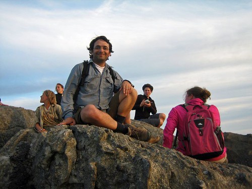
Karijini National Park. The bus picked me up from my hostel at 7 a.m., then stopped at the bus station to load the rest of the passengers. A diverse group included two Americans, me and Tim, a beer-brewing resident of a remote Alaskan island; one Canadian; four Japanese, including Rina, a who was in Australia to improve her English; a Brazilian; and the usual assortment of Europeans, favorite, Liz from England, the Dutch friends Annick and Juliet, and characters from Italy, Portugal and Germany. Ages ranged from 20 to 54, and as we got to know each other it felt like the mix of personalities would bode well for a fun trip.

Our driver/guide was Dan, from Perth, whose interests are limited to the outdoors and chasing women. He briefs us on the trip and then says there is some bad news. A few days before, a cyclone roared through the Pilbara region of Western Australia. Winds up to 275 kilometers an hour caused extensive damage and a few people were killed. It is front-page news in WA. Dan tells us Karijini is closed to all traffic as the situation is sorted out. If we cannot make it through to Broome, we will be forced to turn around and head back to Perth. I fret for a few minutes then decide to worry about it in a few days. We will make it to Broome, but the cyclone will affect the trip in a big way.
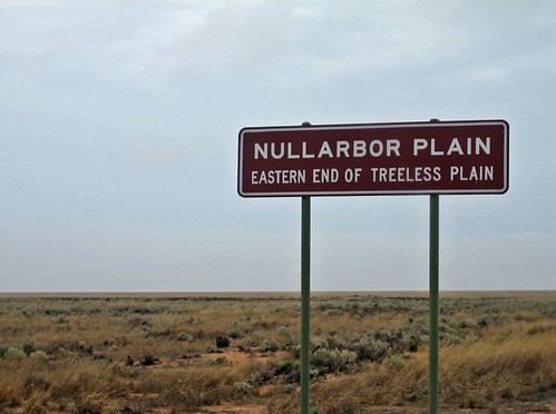
Perth to Kalbarri (March 10, 2007)

Western Australia is the country’s largest state, with about 2 million people. About 73 percent live in Perth, in the southwest. In the country as a whole, there is an average of 2.7 people per square kilometer. In Western Australia, that figure drops to less than 1.

Having traveled more than 7,000 kilometers over land from Sydney to Perth, I appreciate that the country is both vast and empty. Any trip from one place to another covers large stretches of unremarkable scrub and open sky. Miles and miles of highway offer little more than a steady view of flat, open country.

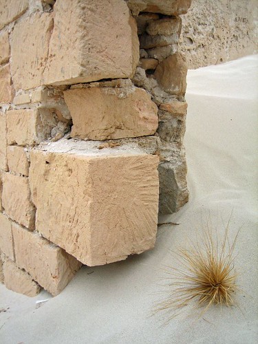
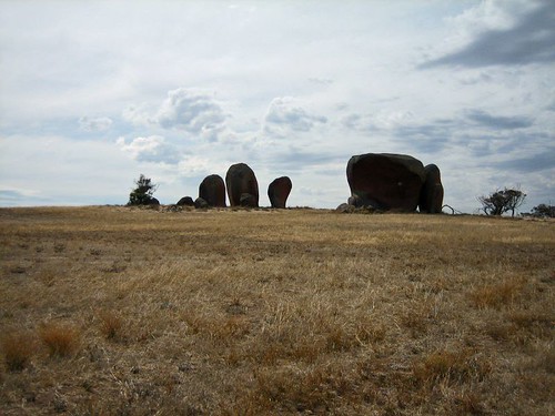
When there is something the break up the landscape (and the monotony), it is most often an unusual natural phenomenon. The Pinnacles in Nambung National Park, 245 kilometers north of Perth, is one natural wonder, and the first stop on the tour.

The park is on the Swan Coastal Plain, an area of shifting yellow sands and coastal heathlands. Out of the yellow sand rise thousand of limestone pillars, a handful more than ten feet tall but most just stumps. Taken alone, each pillar is forgettable. As part of a larger landscape, the Pinnacles are otherworldly, another enigma to marvel over.


The pillars were formed millions of years ago when seashells broke down and were carried inland by the wind. They compacted into limestone and over the years were covered by sand. The dunes stabilized when vegetation took hold, leading to a layer of acidic soil developing over the soft sand below. Over time a hard layer of calcrete formed over the limestone. When plant roots cracked through the calcrete layer, water seeped into the earth and eroded the limestone. What remains today are those areas of limestone that were resistant to erosion (however, they are still eroding today – nothing lasts forever). When winds carried the dunes away, the limestone pillars were exposed.

The Pinnacles reminded me of a site in the Southwest of the United States called Goblin Valley, where toadstool sandstone formations rise from the desert floor. The site was used to excellent effect in the sci-fi farce “Galaxy Quest.”

After the Pinnacles it was a short drive to a series of white sand dunes for some sandboarding. It’s like snowboarding, only slower and you can’t turn. The instructions were to point the board down the dune and hope you don’t fall. The lesson of sandboarding: you are guaranteed to end up with sand in every crevice of your body. Laughing with your fellow travelers as others wipe out at the bottom of the dune is also a great way for the group to get to know one another.

Kalbarri to Monkey Mia (March 11, 2007)

Murchison Gorge in 
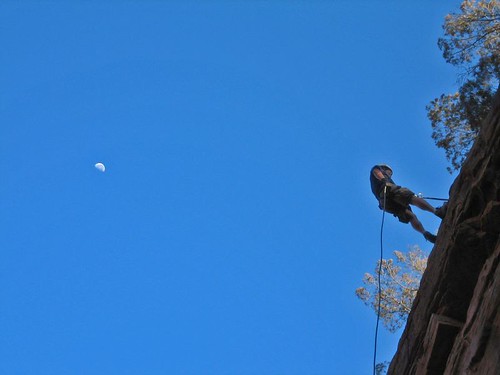
Kalbarri National Park is a preview of what’s to come later in Karijini National Park, a few thousand kilometers north. A river cuts through deep red sandstone to create a scenic gorge. A short hike brings us to a sheer 25-meter cliff, where I take the opportunity to abseil (when did rappelling become abseiling?). I make two trips, first like a normal person with my legs below me, then a gut-busting abseil face down the cliff. I was the first to take the plunge headfirst and am happy to receive a round of applause at the bottom.


A long afternoon of driving and we arrive at Shark Bay, one of 14 World Heritage sites in Australia. The area consists of two small peninsulas that jut into the Indian Ocean. One of these, Peron Peninsula, is the site of Project Eden, a government-sponsored effort to reestablish native wildlife into the peninsula. To do this requires ridding the area of all introduced species – cats, rabbits foxes, goats – and reintroducing native species. To keep the feral beasts out of the area, the government has erected a vermin fence spanning the 4-kilometer entrance to the peninsula. There is a road that the fence cannot cross, but there is a unique solution. Any creature that comes near the fence is greeted by a recording of barking dogs and truck horns.

Shark Bay also features a natural wonder that is one of the reasons I came to Western Australia. I learned about stromatolites when I read Bill Bryson’s travelogue about Australia, which is called “Down Under” in the U.K. and Australia and "In a Sunburned Country" in the U.S. The single-celled creatures were the first living organisms to emerge on the planet. Stromatolite fossils have been dated to 4.5 billion years ago, and were the only form of life on the planet for nearly 2 billion years. They gave rise to other single-celled creatures, then multi-celled organisms. The rest is biological history. They are a testament to evolution and, amazingly, there are a few colonies that survive today.


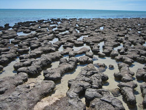
However, stromatolites are not much to look at, merely black rocks in a tidal pool. But with a little backstory, they are fascinating. At least I thought so. Others in the group seemed ready to go after a few minutes.

Monkey Mia to Exmouth (March 12-14, 2007)


The coastal resorts of Monkey Mia and Coral Bay and the town of Exmouth are the main attractions in this part of Western Australia.

Monkey Mia is a resort village best known for the dolphins that show up like clockwork every morning. Tourists gather on the shore for the show, receiving an instructional brief from a park ranger before taking part in a short feeding. The dolphins are wild and must fend for themselves the rest of the day. I think dolphins are interesting, and there was a calf in the group that made an appearance, but the spectacle of a hundred tourists gathered on the shore strikes me as easy entertainment for the masses. If I’d never seen a dolphin before I might have been entertained.

Also depressing was a stop at Ocean Park, a ramshackle, privately owned “aquarium” with a handful of small pools holding sharks and rays and tanks containing sea snakes, turtles and a few poisonous specimens. Ocean Park operates as both a marine rehabilitation facility and a tourist attraction. I don’t know how well they are doing as a rehabilitation facility; as a tourist attraction it was dismal. I was reminded of unscheduled stops in third world countries in which you can witness children making carpets. Nevertheless, seeing a deadly stone fish (you die from the pain, not the poison) and touching a sea snake was worth the $5 price of admission.

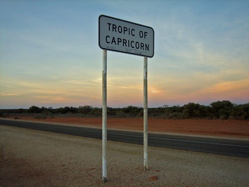
More than 400 kilometers north is Coral Bay. About 50 kilometers from the town, the highway crosses the Tropic of Capricorn. There is a sign and a white line painted on the road. After taking photos, we took turns writing our names on the line with a fat magic marker. I was not amused by Ocean Park, yet the stony stromatolites and a geographical marker in the middle of nowhere gave me great pleasure. What does that say about me? Comments?


Coral Bay is bigger than Monkey Mia. When I say bigger, understand that the population is only about 150. But Coral Bay is a gateway to the Ningaloo Reef, the largest west-coast reef in the world.

One of Australia’s most famous attractions if the Great Barrier Reef, on the east coast in Queensland. I’ve been told that Ningaloo Reef, which is protected within Ningaloo Marine Park, rivals the Great Barrier, but unlike the Great Barrier, which requires visitors to travel by boat to get to the reef, it’s only about 100 meters from the beach. Another big plus for Ningaloo is that it gets a small fraction of Great Barrier’s traffic.

On the morning of March 13, I sign up for a three-hour kayak/snorkeling tour. It’s a short paddle to a spot where sharks gather to clean their gills. Another short paddle takes us to a spot featuring the usual assortment of colorful coral and fish and we see a couple of sea turtles. The water is not as clear as it could be because the night before, the coral spawned. This annual event happens after the full moon in March, when the coral release sperm and eggs into the water. Best not to think about what you are swimming through.


The trip from Perth has included a few days of solid driving, and after kayaking it’s a relief to spend the rest of the afternoon lounging at the beach. The water is warm, the sand is white and the beach is beautiful. It seems like we spend more time floating in the shallows than sitting on the beach, playing like children on a summer’s day.

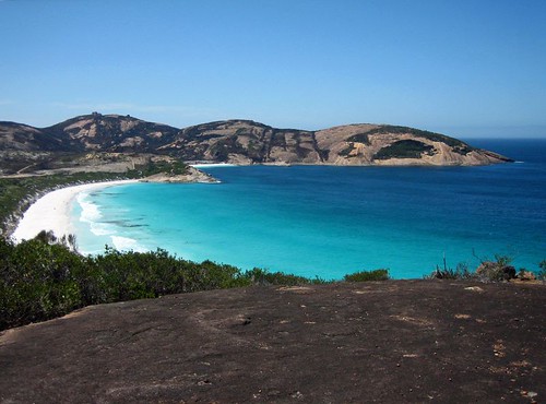
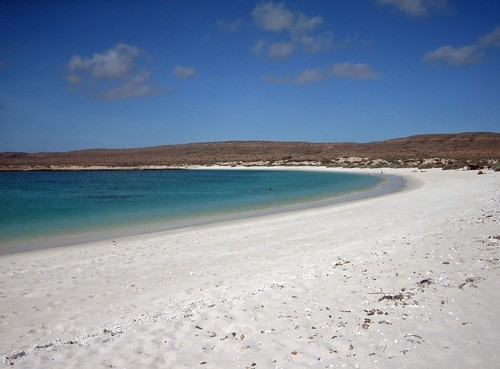
Another 200 kilometers north is the town of Exmouth (pronounced like it is spelled: Ex-Mouth), population 2,500. It is the base for the northern end of the Ningaloo Reef. Sixty kilometers further is Turquoise Bay, one of the best beaches I’ve been to in my life, maybe the best. If Coral Bay was beautiful, Turquoise Bay is exquisite. It’s hard to believe from the perfect conditions that a cyclone roared through the area a week before.

Turquoise Bay is the kind of place I came halfway across the world to experience: remote, relaxing, and extraordinarily beautiful with fun activities and very few people. It’s the kind of place that justifies all the planning, travel, time and money. Of all the beaches I’ve seen in Australia, Turquoise Bay is the one I want to return to the most.


After setting up shelter, about 15 of us gather for a drift snorkel. We walk down the beach, around a point and along a few hundred meters of the reef. There are strong currents and rip tides at Turquoise Bay, strong enough to sweep lazy or weak swimmers out to sea, permanently. And Dan makes sure we know if, saying, “If you don’t make it back to shore, you will be swept out there, and I won’t come after you.”

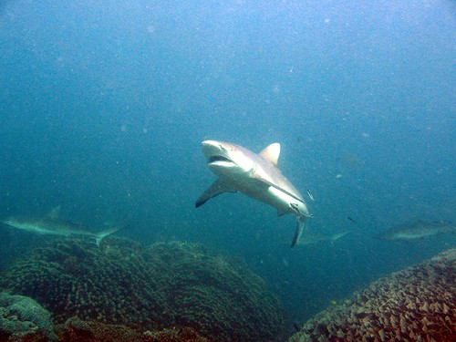
But if you exit the water before reaching the rip, there’s no problem. And since the current along the reef is so strong, you can let the water carry you over the reef, expending little energy other than pointing and oohing and aahing at the marine life below. On the first trip over the reef, as a group, there are no reef sharks or turtles. Later, in the afternoon, I go out again with a small group at high tide. We enter the water and bang, there’s a 4-foot black-tipped reef shark about ten feet in front of me.

The reef shark looks for an escape, gliding quickly left and right before darting off into the murk. But a minute later there’s another one. Or is it the same shark? Same coloration, same size. It swims away. Then a minute later there’s another. This time I’m convinced it’s one shark circling the area looking for food.

Since seeing “Jaws” as a child I’ve harbored an irrational fear of sharks. I previously wrote about swimming with dolphins in Victoria, where a “shark shield” was offered as protection against predators. While snorkeling in Coral Bay and today, there are no man-eaters, but I’m still nervous about swimming in open water with sharks. Once I see them up close, I realize most really are more afraid of me than I am of them. .

Karijini National Park (March 15-17, 2007)


We learn while in Exmouth that the roads to Broome are open and that Karijini National Park is scheduled to reopen by the time we arrive in the evening of March 15. We also learn that because of the cyclone, the tour that left before us was unable to continue to Broome and that there is no bus to take passengers back to Perth. This doesn’t affect me because I’m flying out of Broome, but causes some anxiety for others on the tour.

After all the complaining I did about being stuck in Perth, it ends up benefiting me. If I had joined the tour five days earlier I would not have been able to experience Karijini.

Saying goodbye to Ningaloo Reef, we are on the road most of the day, arriving at Karijini National Park in the late afternoon. The cyclone has fed the landscape, and the park is a riot of deep red rock and bright green scrub. After all the gray, green and white scrub on the coast, the colors are a magnificent treat. I can tell I am going to like this place and I’m haven't gotten off the bus yet.

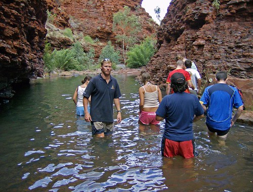
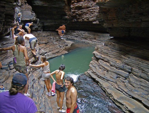
When I booked the tour in Perth, my travel agent described Karijini as “Australia’s Best Kept Secret.” Our guide describes it the same way. I had also seen Karijini profiled in a few travel shows. The love comes from a series of gorges offering the chance to do a bit of canyoneering, a general term a mix of walking, swimming, rock climbing and abseiling through narrow canyons. The most famous hike, called Miracle Mile, is no longer open due to safety concerns, but we are told that we will enter a few of the gorges, some of them no more than 3 or 4 feet wide and a few hundred feet deep, for a taste of adventure.

Up to this point we’ve been sleeping in backpackers’ hostels. Tonight I will finally get the chance to sleep in a swag, which is basically a canvas bedroll with a mattress built in. You roll it out on the ground, put your sleeping bag inside, and sleep under the stars. I had not heard of a swag before arriving in Australia and was very excited about the night ahead.

Not everyone shared my enthusiasm and most spent the night crowded on a huge tarp next to the bus. I chose a spot about 100 feet away, as did three other campers. At about 3 in the morning, I was woken by a scream and saw Julie, a woman from France with little interest in camping, run by my swag. “There was a dog right next to me,” she shrieked. Then she blinded me with her flashlight and begged to know if it was really a dog and whether it was dangerous. I told her it was probably a dingo and that it would not eat her unless she was a kangaroo. Dingo sightings are rare, and the only person who saw it was the one least interested in the outdoors. Unfair. At least I got to see the poisonous red-backed spider that lives in the outhouse.

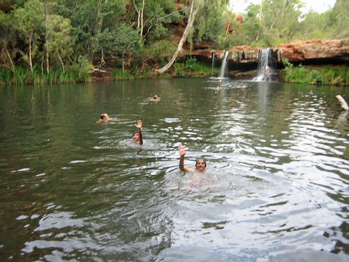
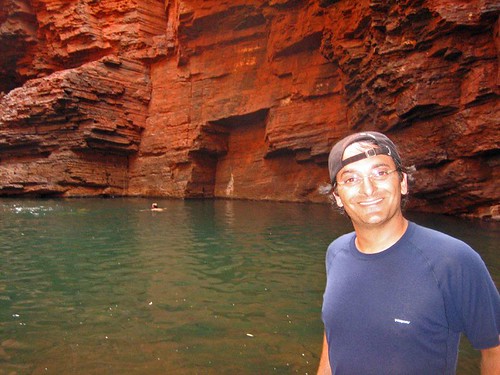
In Karijini over the next two days, we swam in freshwater pools, bathed under waterfalls, squeezed through narrow gorges and traversed rock walls above stony riverbeds. The gorges are imposing and the hiking treacherous. There are many fascinating geological specimens (rocks), including the oldest exposed rock on the planet (about 4.5 billion years old). There was only one minor injury (Marcus, from Germany, twisted his ankle on the first hike) and no one died, even though slipping and falling from any number of places would have resulted sever injury and possible death. When you are 30 feet above a canyon floor, inching along a narrow ledge, you can only think about not falling. I agree with the sentiment that Karijini is Australia’s best-kept secret. It is spectacular. When and how can I return?

One hike worth mentioning was on the morning of our first full day. We walked down a path to Fern Pool, a secluded waterhole with a pair of small waterfalls. After a short swim, we continued down to Fortescue Falls, where a small a trickle washed down the slanted rock. Further down the gorge, there was debris from the runoff after the cyclone, knotted trees and branches and flattened grass. As we approached a side channel to visit a place called Circular Pool, it started to rain, not hard, but enough to get us wet. We continued to the pool and the rain got heavier. A very quick look and we turned around and started hiking up a side trail back to the bus. As we ascended, the rain increased. By the time we reached the top, it was an absolute downpour.


I’m not keen on walking in the rain, but this was an exhilarating experience. In just a few minutes, dry canyon became line with waterfalls. The riverbed we had walked down was visibly higher and would have been impossible to walk along. The landscape changed within an hour from fairly dry to spectacularly wet. We returned by bus to Fortescue Falls, and what had been a trickle was now a torrent. The trail we had taken was completely underwater. I’ll take a soaking in Karijini any day.


Karijini to Broome (March 17-18, 2007)

Not everything goes according to plan on tour. We leave Karijini in the afternoon and set out for a sheep station where we will camp for the night. We will still be sleeping in swags, but we are promised hot showers and flush toilets. The stench in the bus tells me showers are an excellent idea for everyone.

We arrive at the sheep station, a 500,000 square kilometer private farm where there are camping facilities for tourists. We turn off the road and onto a dirt road, where Dan tells the group that we are crossing a dry river bed that becomes impassable maybe one a year when it floods. After about 200 meters, the bus gets bogged in deep sand and we are told to get out and push. No kidding. And we don’t even have to pay extra for the experience. We spend the next 30 minutes digging and pushing to free the bus. We make it across the dry river bed as the sun sets only to travel another 100 meters to discover a wide torrent of water blocking the road. It seems we’ve arrived at the rare time when the river is flowing.

The water is runoff from the cyclone the previous week. There is a truck on the other side of the river, about 100 meters away, and Dan sets off into the river armed with a shovel to test the depth and for stability. The water is never higher than his thigh, but still too high and fast for us to cross in the bus. And we learn when he returns that the cyclone has flattened all the facilities. The farmhouse is standing, but the campground and showers have been destroyed. There’s nothing for us to do but turn around and look for someplace to spend the night. We give ourselves a round of applause for making it out of the sheep station after two rough hours in the dark.

We head up the dark highway for 35 kilometers to a parking area that is nothing more than tarmac and a yellow rubbish bin. We pull in at about 10 p.m., park the bus and prepare dinner. There is nothing but the bus, we campers, tarmac, scrub, the occasional road train on the highway and a billion crickets, mosquitoes (mozzies) and other insects.

It is out last night of the tour and we’ve become a functional group, so we make the most of the situation, preparing dinner and drinking the last of the beer. When a brief spot of rain comes, we take shelter in the sweltering bus. But it passes and we continue our roadside party. There had been two birthdays during the tour and someone pulls out candles and sparklers. Desert, beer, fatigue and sparklers – who needs drugs for a surreal experience?

Bedtime approaches and we lay out our swags in line with the bus, just in case a road train stops during the night. There are still dark clouds in the sky and it looks like there will be no escape from the rain.

I sleep until about 3 a.m., when I feel drops on my face. The scattered drops intensify into a steady rain as people scramble for shelter in the bus. I’m too tired to move so I zip up my swag and cover my head as best I can. It’s too late though, and half of the inside of the swag is soaked with rainwater. Swags are also pretty hot and the enclosed space starts me sweating. Within a few minutes I’m a damp camper. I tough it out and somehow fall back to sleep.

When I wake up before sunrise, only 5 of the 19 campers are outside. The rest have suffered through sauna-like conditions in the bus, getting little to no sleep. Staying out in the run and sleeping in a puddle turns out to be the right choice.

It was a miserable experience, but somehow I’m not too perturbed and wake up fatigued but happy. It’s not the worst night I’ve spent camping. As the sun rises, a perfect rainbow forms to the west, delivering an ironic message I have yet to decipher.

The rest of the day is an exhausting slog over 700 kilometers of empty landscape.


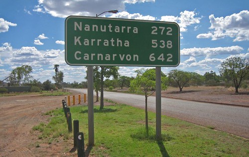
We stop a roadhouse for showers then at another for lunch, but the day is consumed with a the push towards Broome. We arrive in the early evening, exchange hugs and email addresses, and say farewell to a memorable tour.

There is a lot more I could say about this trip. There are logistics and personalities, the monotony of the food and the minutiae of traveling as a group. I hope to get into it all in the near future. In the meantime, if you have any questions or comments, anything you’d like me to write about on Packmonkey, drop me a line.

Flickr Photo Set: Western Australia (206 Photos)

Labels: , ,

Thursday, March 08, 2007

Scarborough Sunset

With a few days to kill before heading north I decided to spend two days at the beach in a Perth neighborhood called Scarborough. The hostel was disgusting and the Mother Nature blasted the city with heatwave. When it’s 108 degrees, the beach is no better than an oven. So I spent 48 hours sweating profusely, downing up to six liters of water a day.

The saving grace was the evenings. Around 6 pm, as the sun began to set, the beach would fill with people – groups of teenagers, couples, families and legions of surfers and boogie boarders. One night the winds were blowing in the right direction and about a dozen kite surfers were riding the currents. Cool evening breezes replaced the torturous heat as the sun sank on the horizon, flattening into a layer of distant orange fire.

Then I ate a double scoop of coffee and chocolate gelato.

Labels:

Hellooooo Cleveland!!

There’s a company here in Australia called Wicked Campers that specializes in renting, yes, camper vans to independent travelers. The vehicles have been individually spray painted in a variety of designs. Some of the designs are obnoxious (“Random Breast Patrol” and three sets of hooters), some reflect Australian culture and heritage (dolphins or Aboriginal artwork) and others riff on popular culture. I’ve seen vans with hip-hop, comic book, movie, television and music themes.

Today I spied the Spinal Tap van – too groovy to pass up a photo op:


Labels:

Message of the Day

Outside a café on Oxford St. in Leederville, a Perth neighborhood:

Monday, March 05, 2007

Roadblock: Do Not Pass Go

I arrived in Perth with a sketchy outline of a plan to get myself a few thousand kilometers north, to a small outpost called Broome – legendary sunsets, camel rides on the beach, etc.. But Perth is the most remote large city on the planet (1.5 million and growing), closer to Bali than to Sydney, and I quickly learned that when you are in the boonies, your options are limited.

I had planned to explore the following modes of transport: rent a car or camper, take a bus or join a tour. The rental option was way out of my price range, the bus would have been a dreary proposition and all the tours for the next seven days were booked solid. Finally, to get a seat on the only available tour leaving in the next ten days, I would have to change the date of my flight out of Broome. When you are on the edge of the world, book ahead. Lesson learned.

So, you might say, just make a few calls and rearrange your schedule. Right? Well… to add insult to injury, by the time I’d worked out a plan on Friday afternoon, it was too late to put it in motion. And today, Monday, is a public holiday (Australian Labor Day) and 99% of the country’s businesses are closed. Luckily, I was able to sort out the flight today with a few calls to a travel agent in Melbourne (thanks YHA Travel!). And I reserved one of the last seats on a tour to Broome.

In short, my weekend visit has turned into a weeklong layover. I consider it the first hiccup of my trip, and it certainly won’t be the last. Now that I’ve sorted out the details, I will be heading 15 km north of the city tomorrow for a few days on the beach.

All in all, these past few days have been taxing but instructive. I’ve spent them at a backpacker’s hostel housing a gregarious mix of young Europeans, most of whom are either looking for work or have just finished working somewhere. I’m getting what I pay for (less than $20 a night to share a room), but there’s a good vibe, lots of laughter and a nice sense of camaraderie.

My first impression of Perth was not good (getting ripped off at a local pub the first night), but after exploring I’ve come to appreciate the place. It’s spread out, with suburbs galore, and if I had a car and the time I think I could come to like it. Perth has the more millionaires than any other city in Australia, so they are doing something right. Perhaps it’s the unspoiled coast, the warm climate or the relaxed pace. Or maybe with nowhere else to go, you make do with what you’ve got. No worries, indeed.

One final note, it was over 100 degrees this afternoon. I wilted.

Labels: ,

Pictures of Perth

Now that you’ve read about my snafu, here are some pretty pictures from Perth. Enjoy!


Perth Skyline from Kings Park:


Kangaroo Sculpture:


Dinosaur Decal Art:

Labels:

Saturday, March 03, 2007

Across the Nullarbor: Part 2

(Note: This is the second part of my Nullarbor adventure. Click here for Part One.)

DAY 4

The rain spit on Fowlers Bay all night long but I was cozy and dry in my tent and slept like a log. Kylie woke the crew at 6 a.m. with am impression of an asthmatic rooster. Having been two hours behind schedule the day before, she was determined to keep up with the itinerary on day four. I crawled out of my tent to a dark wet morning, ready another day as a Nullarbor Traveller.

About an hour outside Fowlers Bay we stopped by the side of the highway for no apparent reason. Kylie explained that we had just crossed the Dingo Fence, the longest man-made structure on the planet (yes, longer than the Great Wall of China). The 5,641-kilometer fence keeps the wild dingos (the dogs that are Meryl Streep’s baby) in the western half of the country. It is meant to protect livestock from the canine predators, but the plan has backfired. Without dingos, feral cats and rabbits have become a huge problem. The government is debating whether to cut holes in the fence every few kilometers to reintroduce the dingo into the east and cut down the cat and rabbit population. (For more on how introduced species create havoc in Australia, rent the fantastic documentary “Cane Toads.”)

Where the Dingo Fence crosses the highway there is a metal grate that the dogs will not cross. There is room to crawl under the road and stick your hands through the grate. A few of us did this for a lark while Kylie snapped pictures.


As we were now on the true Nullarbor, services were few and far between. Most of the traffic is road trains, and the businesses on the route all cater to the trucker drivers. Dotted on the landscape are a handful of “roadhouses” offering fuel, food, showers and toilets and sometimes a place to sleep. Prices are steep and we avoided buying supplies if possible. And no, Patrick Swayze was not spotted at any of the roadhouses.

Just past the Nullarbor Roadhouse we stopped for pictures at the famous Camel-Wombat-Kangaroo Crossing sign. There is little to attract the eye on the Nullarbor other than scrub and sky, so road signs became a major attraction. This one tops them all. Unfortunately, we didn’t see any camels, wombats or kangaroos the entire 96 kilometers.


To break up the drive we stopped at the Bunda Cliffs in Nullarbor National Park and walked through the sand dunes at Eucla to visit the ruins of an old telegraph station on the border of South Australia and Western Australia.

The Bunda Cliffs show three layers of geological sediment. The bottom layer of white limestone was formed between 70 and 90 million years ago when the Nullarbor was covered in ocean. The weather was still overcast but the views were still spectacular. The pictures don’t show the extent of the views. I did enjoy a sign warning tourists of the danger of the cliffs – no words, just a picture of a stickman tumbling to his doom.

The Eucla Telegraph Station used to convey messages between the states of South Australia and Western Australia. Legend says the telegraph operators in each state hated each other and never spoke, even though they spent all day in adjoining rooms. Their only contact came when exchanging telegraph messages. The station was buried by by the sand dunes for about 80 years, when vegetation kept the sand in place. But rabbits ate all the foliage and the sand shifted again, exposing the ruins below.


Day four ended with a night of true bush camping – no facilities, no neighbors, nothing but our crew and the desert. Kylie taught me how to make damper, Australian bread. You mix flour, self-rising flour and water, throw in a few dried fruits, knead and shape, then sprinkle the top liberally with sugar. Once the campfire embers are nice and hot, you put the loaf into a covered pan and place in the fire. Twenty minutes later, you’ve got yourself a loaf of doughy, sweet bread. Slice and top with yogurt and Bob’s your uncle. (I don’t actually know what “Bob’s your uncle” means, but I like the sound of it.)

DAY 5

Kylie made an executive decision on day five to forego another night of bushcamping in favor of a long day of driving to Lucky Bay at Cape Le Grand National Park, where we would set up for three nights in one location. Along the way we stopped to stretch our legs at a two of the caves on the Nullarbor. As I’ve mentioned, the Nullarbor is composed of limestone, which is prone to erosion, which forms caves.

The Nullarbor Traveller tour used to include an afternoon of swimming in an underground freshwater pool at Cocklebiddy Cave. But a cave-in a few years ago left the cave unstable and the Parks Department closed it to visitors.

There is also an interesting story associated with Cocklebiddy Cave. About ten years ago, a group of scientists set out to map the cave using scuba equipment, spelunking up to four kms under the desert floor. One day an Aboriginal woman, Maureen, appeared out of the bush and told the scientists that Cocklebiddy is a sacred Aboriginal site and that should ask the Rainbow Serpent (a vital player in many Aboriginal creation stories) for permission before entering the cave. The scientists scoffed at the idea and entered the cave. Observers claim a brown snake appeared in the desert and followed the men into the cave.

Soon thereafter, a cloud in the shape of a snake appeared in the sky and let loose with a torrential downpour, dropping 40 milliliters in an hour in a region that gets less than that annually. The cave entrance crumbled, trapping the divers inside for two days. When they were finally rescued, witnesses saw the snake follow the men out of the cave.

I don’t know if I believe this story, but the storm was documented and multiple witnesses claim they saw the snake and Maureen. Was she a ghost? Was the snake the Rainbow Serpent? Nobody knows.

Back into the bus for the long drive to Lucky Bay we cover the 90-Mile Straight, the longest stretch of straight road in Australia, and then stop in Balladonia for fuel and to admire a piece of Skylab mounted on the roof of the roadhouse. I remember hearing about Skylab falling from space in 1979. The news described the area as a remote part of “Outback Australia.” I never intended to visit the area but was pleasantly surprised to pass through. The small museum documenting the event was closed for repairs. I will have to look it up on Wikipedia someday.


We arrived at Lucky Bay as the sun was setting, and after logging 731 kilometers on the day set up camp for the next three nights.

DAY 6

For the first time on this trip, I slept past 8. I woke to kangaroos, a mother and her joey, nibbling their breakfast in the middle of the campground, unconcerned about the humans in their midst.

We piled into the bus for the 50 km drive to the city of Esperance (Population 15,000), the first town of any significance that we’d seen since Port Augusta on day one. After just five days in the bush, I was struck by our return to civilization. I’m a big fan of electricity (and hot showers), a fact I’m sure of after being without for a few days.

We toured the town’s white-sand beaches, rated as the best in Australia, before Kylie let us loose for 90 minutes of lunch and shopping. I ate a huge hamburger, caught up on email and bought an Australian power chord for my laptop.

Back at Lucky Bay, the wind was whipping and the sea too rough for swimming. So we made a mockery of cricket on the beach before a late afternoon bushwalk.

In the late afternoon, we set out for Frenchman Peak, a granite mountain no more than 800 feet tall, but still the highest feature of the landscape. A slow, steep climb brought us to the top of Frenchman, the wind whipping harder and keeping me off balance while enjoying the 360-degree view. Kylie handed out squares of toilet paper and we all let go at once to see whose square would fly the farthest. Mine landed in a bush about ten feet away.


Back in camp, Kylie said it was time to learn about the Tim Tam orgasm. I broke out the bottle of Jack Daniel’s I’d bought in Port Augusta and Kylie brought out the Tim Tams. Tim Tams are made of two rectangular cookies with a cream middle and a chocolate coating. The trick is to nibble off opposite corners, then suck the Jack Daniel’s from a cup into the cookie’s interior. Crunch, smile, yum. You can use milk, tea, coffee, any liquid you want instead of Bourbon. But the combination of Jack Daniel’s and chocolate is hard to beat.


DAY 7


The morning of our second full day at Lucky Bay was spent hiking from Cape Le Grande Beach to Hellfire Bay, a 3-hour trek through coastal scrub, over marbled granite slopes and across a beautiful white sand beach. The swim with the sea lions on day two will forever be the highlight of this tour, but this hike ranks a close second. It felt great to get out and spend quality time tramping through the bush.


After the hike, a swim in the crystal clear water at Lucky Bay and then a BBQ dinner that included kangaroo sausages (‘Roo Bangers). The meat is tasty, not like chicken, but the prospect of kangaroos bouncing through camp while I was chomping on a sausage dampened the experience.

DAY 8

Not every day on a tour can be great, and day 8 sucked.

Here’s the short version: a long day of driving, no hike at Bluff Knoll due to bad weather, the winery shut for the day and the land around the campground decimated by a bushfire the week before.

Still, it was nice to leave the desert behind and enter a landscape with forest and greenery. We also passed through the Fitzgerald Biosphere, an area of 330,000 square kilometers where 75% of the plants and animals do not occur anywhere else in the world. One example is Australia’s most deadly snake, the Dugite. We didn’t see one.

DAY 9

With mixed emotions, I rose for the last day of the tour. It had been a lot of fun, and we’d covered a lot of ground, but I was ready to see a city and check in with the news of the world.

There rain continued as we entered the Valley of the Giants outside of Walpole for a tree-top walk among old-growth Red Tingle eucalypts. A series of suspension bridges form a 600-meter loop through the forest canopy. The steel walkways sway 40 meters above the forest floor, offering spectacular views of the trees and the ground below. As we begin the walk, the clouds part, the sun starts shining and the whole forest glistens.


We stopped for lunch at the Diamond Tree Fire Lookout, a eucalypt more than 50 meters tall with a series of spikes circling the truck to form a ladder and a small cabin perched at the top. A fire ranger would climb the tree in the morning and spend all day scanning the horizon for smoke. A small black PVC pipe carries waste from the top to a chamber on the ground. I climb about 30 feet before freaking out and descending for lunch. Without ropes or a harness, it felt too high, too exposed and too unsafe for a 40-year-old with wonky depth perception.

A few hours later, we pass through Bundury and Kylie points out the first traffic light in 3,900 kilometers. An hour later we are in Perth and the tour is over. We’ve covered the distance from London to Moscow with no injuries, no fights and smiles all around.

When I look back on my nine days crossing the Nullarbor, I recall the swim with sea lions, the desolation of the plain, the road trains, hiking and camping at Lucky Bay. The names of towns run through my mind – Iron Knob, Widunna, Venus Bay, Streaky Bay, Penong, Fowler Bay, Caiguna, Balladonia, Eucla, Madura, Esperance, Jerramungup, Porongurup – places I will probably never see again, but am happy to have seen once. If you are ever in Australia with nine days to kill, travel across the Nullarbor. You won’t regret it.

Flickr Photo Set: Across the Nullarbor (147 Photos)

Labels: , ,

Friday, March 02, 2007

Across the Nullarbor, Part 1

Howdy! I’m in Perth after a nine-day trip that included the Eyre Peninsula, the desolate Nullarbor Plain and the forests of southwest Western Australia. The tour was everything I hoped for and a little more.

I came to Australia with the goal of crossing the Nullarbor. A solo traveler’s options for the Nullarbor are limited. Trains and buses make the journey in two days. You can rent a car and drive yourself. Or there’s the Nullarbor Travelller, a private tour company offering a nine-day tour from Adelaide to Perth with a few adventures along the way. I decided this was the best for me and signed up.

The world Nullarbor comes from the Latin Nullus Arbos, meaning treeless plain. The actual area of the Nullarbor that is treeless is just a fraction of the whole, but the area is still dry, hot and remote. It is the world’s largest, flattest piece of limestone, covering an area or approximately 200,000 square meters. The Aboriginal word for the region means “place without water.” Even today, large swaths of the Nullarbor generate their own electricity (from solar or wind power) and subsist on reserves of rainwater.


DAY ONE

The tour began with a 7 a.m. pickup at my hostel in Adelaide. The guide and driver is Kylie, a former hairdresser who decided to change careers and in her early 30’s finished high school, went to college for a degree in biodiversity and conservation and is now working as a guide until she can become a park ranger. Kylie dislikes of the city, “The Big Smoke” she calls it, and I can tell she is itching to get on the road. Her enthusiasm is infectious and soon her seven passengers are settled in for the adventure ahead.

Over the next nine days we will cover nearly 4,000 kilometers (2,500 miles), traveling through mountain ranges, coastal towns, desolate desert and old-growth forest.

We head north on A1, past farmland and dry salt lakes before reaching sleepy Port Germein to pick up our trailer – food, gear and general necessities for the road ahead. A few kilometers out of town we see the lower reaches of the Southern Flinders Ranges. Australians call these mountains, but with the highest peaks topping out at about 1,200 meters, most people (me, for one) would call them hills.

We stop at Mr. Remarkable for a short bushwalk while Kylie prepares lunch. It is here that I spot my first live kangaroos, unremarkable specimens we spook on the trail. I’ve seen plenty or ‘roos on film, but until I’d seen them hop with my own eyes, I didn’t understand the power of their legs and the grace with which they move. I have also learned (courtesy of the Lonely Planet guidebook) that the hopping motion assists in breathing, as the up and down motion jostles the intestines, which in turn pump the bellows of the lungs. After two weeks in Australia, I am happy to finally see these creatures. There will be many more before we reach Perth, but this is a load off my mind.


The afternoon also brings a change in scenery. The white limestone so prevalent on the coast gradually turns to a coppery red as we enter the inconsequential town of Port Augusta, once the center of the country’s mining industry. The town is also called the crossroads of Australia, with railroad and automobile routes north to Alice Springs and Darwin and west to Perth passing through. A quick stop for fuel and supplies (an overpriced bottle of Jack Daniels for me), we head to the defunct mine at Iron Knob.

With almost 800 kilometers to cover on the first day, I assume the tour’s operators wanted to break up the journey with something, with anything. What we get is a visit to the mine at Iron Knob. The town once housed 3,000 souls, but the land has been stripped bare and Iron Knob is little more than a historical curiosity. The visit is not something I would ever do on my own, but I enjoyed seeing a mine pit and the old machinery.

Next up is a short stop in Kimba, a town exactly halfway across the continent, for photos with another example of Australia’s oversized statues. This time it’s the big galah, a native bird with a shocking red breast. We also get our first look at road trains, the semi trucks carrying two or more trailers that ply Australia’s highways and dirt tracks. Road trains once carried up to seven trailers but are now limited to three on sealed roads and four on country tracks. At a Mobile Station outside of Kimba, the sign advertises the availability of petrol rather than the price.


We set up camp at Polda Rock, outside of Widunna. With a small group, there are tents for everyone and I am happy to know I will have a private room every night for the next week.

DAY TWO

The next morning, we drive an hour to Baird Bay, a protected cove where we sign up for the Baird Bay Ocean Eco Experience. It costs an extra $100 AUD, but I’m not about to pass up the chance to with wild sea lions and dolphins. The dolphins are skittish and swim away after about a minute, but the sea lions are happy to swim and play for about 40 minutes. (Click here for a detailed post on the swim).

After lunch on the beach in Baird Bay, we head to the geologic oddity Murphy’s Haystacks, where huge hunks of granite have been left exposed after hundreds of thousands of years of erosion. Good for pictures and the young geologist on the tour, but in the end not more than a curiosity. Kyle took me into the toilet to see a black widow, but it wasn’t in there, just egg sacks and a puny male.


The final activity of the day was a walk along the limestone cliffs at Venus Bay to see petrified trees, from a time when Australia and Antarctica were one landmass. Kylie also offered a lesson in identifying animal tracks in the sand. I can now spot a few kinds of lizard, snakes, emus and humans.

The second night we bunked at Coodlie Park, a ramshackle farmhouse operated by the owners of Nullarbor Traveller. A lukewarm shower, some electricity for my computer and a barbecue dinner completed a spectacular day in South Australia. From here on out it would be camping and tents every night.

DAY THREE

The third day of the tour started with a pleasant surprise: surf school. I grew up on the coast and tried to surf as a young teenager. I was never able to stand up and ride a wave. With a few simple instructions from Chris of Kingo Surfing, I entered the water and was standing up and riding waves in a matter of minutes. It helped that I was riding a huge soggy board. The fun of surfing, a private beach and clear green water took my mind off the great whites.


Surfing was a ton of fun, even if the sky was overcast and the wind was blowing. We next headed up the road to Ceduna to restock supplies for the next few nights.

Unfortunately, a late start, a long surf and an even longer lunch put us two hours behind schedule. We didn’t’ have time to stop at Cactus Beach, a famous surf break favored by the world champion surfer Kelly Slater.

We were also so behind schedule that I was unable to go sandboarding in Fowlers Bay, our stop for the night. I’d so been looking forward to shooting down a sand dune on a wooden board. Nevertheless, I’m on holiday and in no position to complain.

And then rain came.

I’ve mentioned how Victoria and South Australia have been suffering from drought, and the rain was a welcome sight for the locals. For our band of travelers, it meant a night camping under the unceasing pitter-patter of raindrops and a sodden morning packing wet tents. For a trip through the desert, this was turning into one soggy experience.

Next: the treeless plain, the camel-wombat-kangaroo sign, and a town covered by sand.

(Photos from the whole nine days are posted here. I will write the rest of the journey tomorrow.)

Labels: , ,

Sea Lion Party

On the second day of my trip from Adeliade to Perth, I was given the chance of a lifetime – a swim with wild sea lions and dolphins. The operators of Baird Bay Ocean Eco Experience, Allan and Trish, have been visiting the sea lions and dolphins of Baird Bay for more than ten years. Over that time, the animals have slowly come to realize the humans are not there to kill them. Unlike most wild animals, which will retreat as soon as humans approach, the sea lions and dolphins in Baird Bay accept the presence of humans and will behave in ways that could be described as playful when humans are around. The animals have never been fed, and as Allan described it, we humans were the attraction for the animals. How much time we spend in the water is determined by how much interaction the animals want to have. If they swim away, we go home.

After donning wetsuits, we boarded the boat and received our instructions from Allan and Trish. Basically, the rules were simple. Don’t touch the animals, remain calm and let them come to you.

Usually, the tours start with the sea lions. But the tide was unseasonably low so we headed into deeper water to track down the dolphins. The water is not entirely open ocean, but it is deep enough to include the local shark population, which includes great whites. With safety in mind, the guides wear electronic “shark shields” when they lead the tourists into the water. The devices emit signals that great whites and other nasties with big, sharp teeth find intolerable. Even so, the idea of jumping into water with sharks is my worst nightmare. I sucked it up and trusted the technology.

Nevertheless, our first attempt to swim with the dolphins was a bust. There were dolphins in the water, but as soon as we lumbered into the drink they took off.

Allan and Trish shifted gears to the sea lions. We motored to a secluded part of the bay, where a limestone reef protests the animals, and the humans, from predators. The water was only about 7 or 8 feet deep and no shark shields were necessary. We received out instructions again and entered the water.

Sea lions are smart mammals. When our group entered the water, it felt like they were checking us out. We’d been instructed to remain calm, to swim slowly with our arms and to not kick, and to never approach or try to touch the animals. The opening minutes of the swim were like an introduction, with each sea lion taking the time to look at the swimmers and suss out the situation. They would sit on the bottom of sea or swim slowly around us, sniffing and looking us over. The group of half a dozen sea lions was mostly made up of juvenile, (about 3 or 4 feet long) but one giant bull (8 feet long and a handful of fish fillets shy of 400 pounds) decided he’d like to play as well. Allan later said the appearance of the bull was rare.

As the humans and sea lions both became more comfortable, there was more movement on each side. Some of the humans dove to the bottom of the shallow pool and the sea lions responded, swimming faster and corkscrewing through the clear water. As I became more comfortable I would also dive, swim upside down or spiral through the water, and every time I did this I’d find a sea lion close by, often just inches away, gliding past me and checking me out.

After twenty minutes, the sea lions pickup up the pace and were showing how fast and graceful they can be underwater. Some of the younger ones would nip and each other at the bottom of the pool or avoid a human by jumping clear out of the water. At this point I would turn around to find whiskers in front of my face or look down to find a furry face gazing up at me. I would have stayed with the sea lions all day, but fatigue set in and I returned to the boat. The sea lions just kept playing.

We made a second attempt to swim with the dolphins. It was more successful – they stuck around for about one minute then bolted. It was long enough for a good look but too short to play. The sea lions made up the dolphins’ lack of interest.

My fellow Nullarbor Traveller Dawn has posted some photos of the sea lions on her Flickr site.

Labels: , ,